Lec: 9/9 | Processing and Interpreting the Wenner VES data from Thursday, September 3rd.
We took a look at how to use RES1D, a simple program for inverting Vertical Electrical Sounding data like the Wenner VES data we collected at the Dog Leg last week, or Schlumberger VES data (which we haven't discussed yet).
There are "mechanical aspects" to the process:
What does the data input file look like, i.e. field_data.dat ?
How can you use a text editor to create/modify a .dat file?
How to invert and display the results. You can also recreate the data from the resulting .inv file, and save the plot of the results as a bitmap .bmp image.
How to read the displayed results
How to think about reducing the number of layers the software presents to be more consistent with your geological model of the field site. This is quite important.
How does a simple layered resistivity structure "look" in apparent resistivity field data - we did one brief example, more later when we do forward modeling. Look at pages 189 - 191 of the reading handout I gave you.
... perhaps other things ...
In the future we will learn how to use RES1D for *forward modeling of 1D resistivity structures - this helps us gain intuition about resistivity data.
More interesting (I hope) was the discussion of the geologic interpretation of the RES1D results. Was the four-layer preliminary geologic model consistent with the electrical resistivity inversion results? We didn't quite get enough time to finish that off, but we will soon.
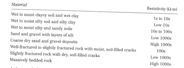
As part of that process, we will need to consult tables of electrical resistivity values. For example on page 183 of this reading, or this table. Many others exist.
As an activity for yourself you should start from scratch with fresh blank paper and
Think about the Dog Leg field site (no geophysics) and think through the reasoning behind our preliminary geologic model (PGM). We have competing ideas that the structure is in some sense layered, but then also that there are lateral/horizontal heterogeneities. How can we think of this multi-style deposition occurring? Why are paleochannels a possibility to be buried in the subsurface? What other types of lateral heterogeneity may exist?
Given the discussion about this preliminary geologic model, do you agree with it? Is there anything you would add to it? Remove? Critique it, and modify your own personal version accordingly.
What electrical resistivity values might you assign to the layers (layers broadly defined) in your PGM? Are possible materials seen in the electrical resistivity tables broadly consistent with the materials you think are in the subsurface? In other words, can you reconcile the inverted Wenner VES result with your PGM?
Are either of our bedrock candidates consistent with the inverted data?
Create a sketch that your geologic reconnaissance and inverted data into an annotated sketch that summarizes our opinion of the structure of the field site right now. Would you be confident in knowing where and how deep to drill a groundwater well?
If so, you should be able to clearly articulate why.
If not, you should be able to clearly articulate the confounding issues, and what type of geophysical data may help you get past it.
Lab: 9/10 | SuperSting practice on Baker Lawn
Laying out cables at less than 10-meter spacing.
Connecting electrodes to cables
Cuyama Valley Field Trip*: Fri 9/11 - Sun 9/13
Collect a maximal SuperSting profile - 112 electrodes at 10-meter spacing
Observe Morales Formation and Qya for later use in interpreting collected data
Meet Iason and others from SDSU.