The Essentials of Plate Tectonics
Plate Tectonics Part I | Back to the GEOL 102 Homepage
The Essentials of Plate TectonicsIntroductionSummaryExpanding The Notion of a PlateSimplified Earth Structure in Cross SectionNotes and CommentsThe Annotated SketchAnimated Illustrations of Plate Tectonic Concepts1. Plate Boundaries - What are the lithospheric (tectonic) plates?2. Tectonic Plates vs. The Crust - Why is Earth's crust often mistaken for the tectonic plates?3. What are the driving forces for Plate Tectonics?4. What are the three types of plate boundaries?Some key ideasConfiguration of plates in the past - and the future (?)SlidesAdditional Plate Tectonics Resources
Introduction
Maybe you have heard of the term plate tectonics before. But what does it mean? Let's look at the words separately. Here is a dictionary definition (source) of tectonics:
Now what does the word plate mean in the geologic context of plate tectonics? Well - we will get to a more precise definition below. For now, here is the arrangement or assemblage (at least in map-view, i.e. we can't see the plates below the surface representation here) of earth's tectonic plates:
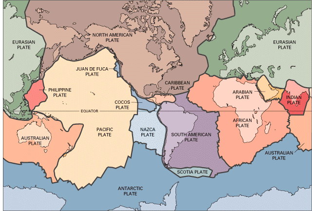
This image takes a little getting used to - note that the land masses are generally the lighter colors while adjacent oceans are darker shade of this color (for example, look at the Eurasian plate at the top right of the image).
Take a look at the plates to get familiar with their names, sizes, where they are, etc. Having a visualization in mind is useful for thinking about plate tectonic processes, and geology in general (and lots of other things too).
A Few Questions:
Are plates the same as continental land masses? In other words, is the South American plate made up of just the continent of South America?
What are some of the largest and smallest plates (with the caveat that a rectangular map projection - any map projection - like this introduces some distortion into the image)?
Find Iceland (east of southern Greenland). What's interesting about the location of Iceland with respect to plates?
Summary
Plates are made up of both continental and oceanic land masses (by oceanic land mass it is meant that beneath the water there is solid earth, or land mass). To state this more simply, we can say that in most cases plates contain both continental and oceanic crust.
Expanding The Notion of a Plate
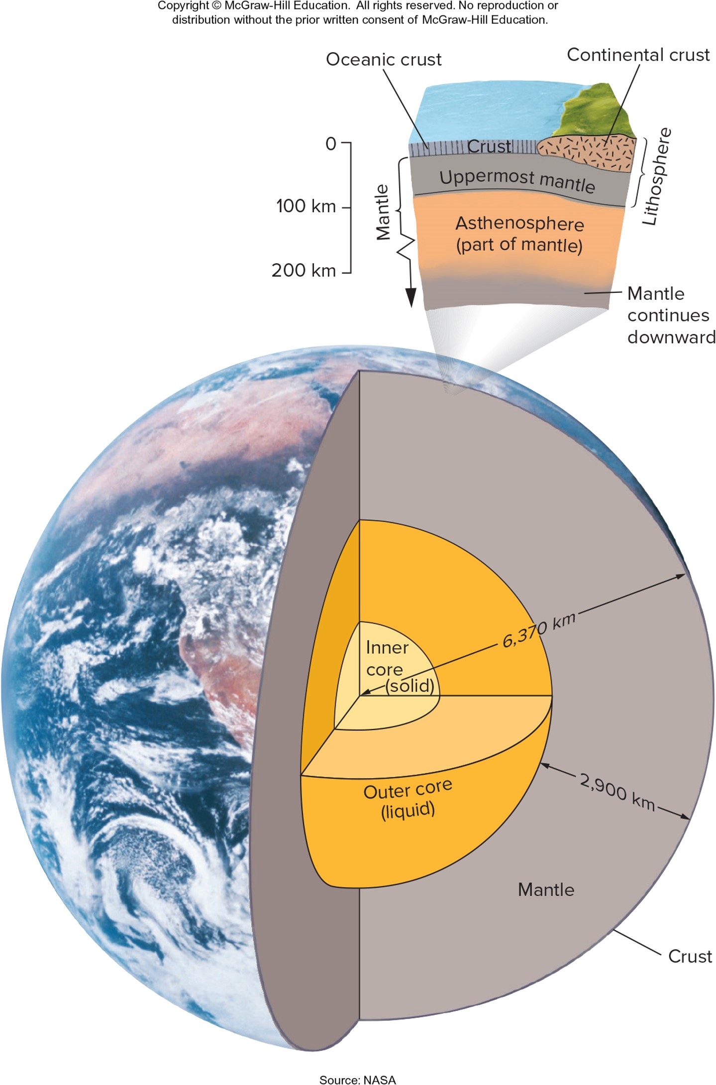
Knowing that plates are made up of continental and oceanic crust at the surface, and since we can only see the surface of the plates in the above image, it is natural to ask: how thick is the continental crust? the oceanic crust?
Answer:
The continental crust has an average thickness of about 35 km (1 km is
The oceanic crust has an average thickness of about 7 km, with a range of about 5 - 10 km.
Why these two types of crust have different thicknesses and elevations will be discussed later1
So it that all there is to a plate? No. But to continue we need to look at a bit of deeper earth structure.
Simplified Earth Structure in Cross Section
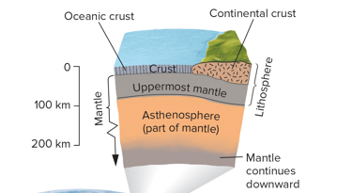
In Figure 1 below an entire earth cross-section is shown, with a more detailed cut-out of the uppermost 200 km. This cut-out highlights part of earth's mantle and also what is called the lithosphere.
Note that the lithosphere contains the continental and oceanic crust discussed above, but also contains a region called the uppermost mantle. Putting it all together, the lithosphere of the earth is made up of the uppermost mantle and the overlying continental and oceanic crust.
It is the lithosphere that is broken up into lithospheric plates, or tectonic plates. These are the plates of Plate Tectonics.
Notes and Comments
The markings and coloring of the continental crust, oceanic crust, and uppermost mantle (also referred to as lithospheric mantle) in the figure above is not an accident. They are different colors because of their different composition, and the markings are meant to indicate something about the composition and structure variations — stay tuned.
The overall thickness of a lithospheric plate (or, just a plate) is about 100-150 km.
The continental crust, oceanic crust, and uppermost mantle, all have different mineral/rock compositions, and thus different densities.
Density of the continental crust:
Density of the oceanic crust:
Density of the uppermost mantle:
This is represented in the Figure 2 below:
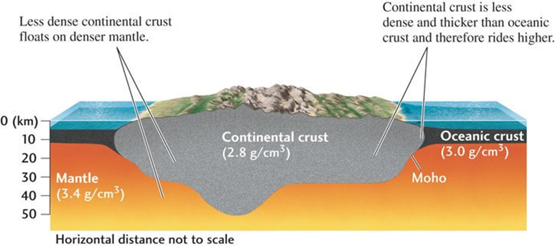
🠩 Figure 2. Close view of a lithospheric plate - we will fill in more details about compositional variations in each of the parts → continental and oceanic crust, and uppermost mantle (or lithospheric mantle) .
The reason the uppermost mantle is part of a (lithospheric) plate is because it is rigid. This is in contrast to the rest of the mantle (the underlying asthenospheric mantle and the "rest of the mantle") which is involved in mantle convection → see your reading about this for now.
The Annotated Sketch
Let's examine the cut-out from Figure 1 in isolation below (Figure 3):
Question: Suppose you were now asked to make an annotated sketch of a lithospheric plate. What would you draw? What does annotated sketch mean?
🢂 Let's do this as a short class activity.
Animated Illustrations of Plate Tectonic Concepts
1. Plate Boundaries - What are the lithospheric (tectonic) plates?
🠪 Alternatively play the mp4 file locally: Plate Boundaries - What are the lithospheric (tectonic) plates? or, right-click the link to download the mp4 file.
2. Tectonic Plates vs. The Crust - Why is Earth's crust often mistaken for the tectonic plates?
3. What are the driving forces for Plate Tectonics?
4. What are the three types of plate boundaries?
Types of plate boundaries? {might play in the browser} or, right-click to download the mp4 file.
Some key ideas
Types of plate boundaries and their motions;
Where you would an example of each type of plate boundary?
What is the lithosphere or lithospheric plate ?
A few more plate tectonic animations are here
Here is a an overview of the lithosphere (Figure 4) - but is not annotated with thicknesses or densities
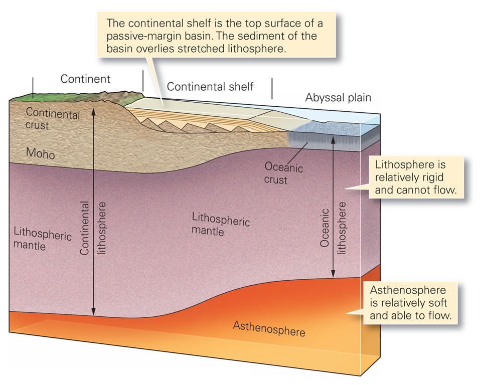
🠩 Figure 4. Structure of a lithospheric plate. Note that this does not have the information we have discussed about thicknesses, densities, etc.
Configuration of plates in the past - and the future (?)
What did the earth look like up 750 million years ago? i.e. run the plates backward in time.
Pangea to present {might play in browser, otherwise right-click and save to your computer}
Question: Can you think of any ideas for how this past lithospheric plate motion was determined?
Slides
Sometimes I will post slide sets on my webpages corresponding to the chapters we read. However, it is important to note that these slide sets are not meant to be a primary learning resource for you.
I use them in class to view a useful figure, or to have some images at the ready to help answer questions with, etc. The slide sets are not necessarily linearly arranged or organized. You should really only use them after you have otherwise "digested" the course material - otherwise you will probably just become confused by them.
With that disclaimer in mind: Essentials of Plate Tectonics - slide set resource. "Right-click" to download.
Additional Plate Tectonics Resources
Footnotes